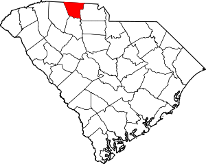


Please add profiles of those who were born, lived or died in Cherokee County, South Carolina.
History
This area was occupied for thousands of years by indigenous peoples and by the historic Cherokee people before European encounter.
When European traders and settlers entered the area, they used the existing Native American paths: called collectively the Trading Path. The Upper Road and Lower Cherokee Traders Path were paths that passed through the piedmont. The former connected to Fredericksburg, Virginia, leading from the Virginia Tidewater into the Piedmont and to the South. The Lower Cherokee Traders Path especially connected areas in present-day western North Carolina, northern South Carolina and northeastern Georgia. In the mid-18th century, waves of British migrants and immigrants, an estimated 250,000 people, traveled by these paths into Cherokee and neighboring counties in the piedmont. This backcountry area was initially settled especially by immigrant Ulster Scots people, Germans and Anglo-Americans migrating into the area.
In later years, some plantations were developed and black slaves were brought into the area as labor.
The Battle of Cowpens, a decisive engagement of the American Revolution's southern theatre, was fought on January 17, 1781, in northwestern Cherokee County, north of the town of Cowpens.
Adjacent Counties
Cities, Towns & Communities
Links
Roots & Recall - Cherokee County
National Register of Historic Places
Kings Mountain National Military Park
South Carolina Digital Library
