


_(14589740028).jpg)


The object of this project is to assemble information about South African Towns and Cities, the dates they were established and where possible record information about the founders and origins of the place names. Where those who were instrumental in establishing the place have a GENi profile please link them to the project in bold.
NB When adding place names to events in profile information please use the place name as it was at the time of the event. If you use the "start typing ..." for place name it will fill in the modern place name. The solution is to - manually fill the place name in reading from your original source. The lists gathered in the pages linked to this project can help establish the names of place at the time events took place Historical Province and Post 1994 Provinces are added under each place name in the listings.
Gratitude and thanks to June Barnes for compiling this project -- Phillipp
![]() South Africa - Towns and Cities A-C
South Africa - Towns and Cities A-C![]() South Africa - Towns and Cities D-G
South Africa - Towns and Cities D-G![]() South Africa - Towns and Cities H-K
South Africa - Towns and Cities H-K![]() South Africa - Towns and Cities L-P
South Africa - Towns and Cities L-P![]() South Africa - Towns and Cities Q-S
South Africa - Towns and Cities Q-S![]() South Africa - Towns and Cities T-Z
South Africa - Towns and Cities T-Z


 The Union of South Africa was established in
1910 by combining four British colonies: the Cape Colony, the Natal Colony, the Transvaal Colony and the Orange River Colony (the latter two were, before the Second Boer War, independent republics known as the South African Republic and the Orange Free State). These colonies became the four original provinces of the Union: Cape Province, Transvaal Province, Natal Province and Orange Free State Province.
In the 1950s "homelands", also called "bantustans" were consolidated. Four of these homelands were established as quasi-independent nation states of the black population during the apartheid era. In 1976, the homeland of Transkei was the first to accept independence from South Africa, and although this independence was never acknowledged by any other country, three other homelands – Bophuthatswana (1977), Venda (1979) and Ciskei (1981) – followed suit.
In 1961 formal nahttps://www.geni.com/project-10223/edit#me became been the Republic of South Africa, Republiek van Suid-Afrika in Afrikaans. Since 1994, the country has had an official name in each of its 11 official languages.
On 27 April 1994, the date of the first non-racial elections and of the adoption of the Interim Constitution, all of the provinces (Cape Province, Transvaal Province, Natal Province and Orange Free State Province), and homelands, (Transkei, Bophuthatswana, Venda and Ciskei) were dissolved, and nine new provinces were established.
A major change was the redivision of the country into eight provinces:
https://en.m.wikipedia.org/wiki/Eastern_Cape
Bartolomeu Dias on 12 March 1488, named it the "Cape of Storms" (Cabo das Tormentas). It was later renamed by John II of Portugal as "Cape of Good Hope" (Cabo da Boa Esperança).
 British Kaffraria - The British Empire
The eastern regions of the Cape were attacked by the Xhosa in 1834, followed by Xhosa territory being invaded by the British. The result was a new territory named the Province of Queen Adelaide, which was rescinded in 1836.
Frontier war - the Cape colony's borders were pushed eastwards. On 23 December 1847 the lands between the Keiskamma and Great Kei Rivers were annexed to the Cape Colony. The new territory, known as British Kaffraria, which was divided into seven counties
Frontier war - the Governor of the Cape, Sir George Grey, established missionary training institutions at
In 1857 veterans of the British German Legion were brought out as military settlers to Kaffraria, resulting in the establishment of a number of new settlements, such as Berlin, Stutterheim and Hamburg.
In 1859 East London was incorporated into British Kaffraria, and in 1860 the territory was proclaimed a Crown Colony with divisions at
British Kaffraria was annexed to the Cape Colony and divided into two divisions,
British Kaffraria was further fragmented into the divisions of
 Transkei
 Ciskei
At the end of the 19th century, the area known as British Kaffraria between the Fish and Kei rivers had been set aside for the "Bantu," and was known as the Ciskei from then on. Europeans gave the name Ciskei to the area to distinguish it from the Transkei, the area north of the Kei. Ciskei had self-government in 1972, Nominal independance in 1981 and was re-integrated into South Africa in 1994.
After 1910 British Kaffraria became known as the Border Region.
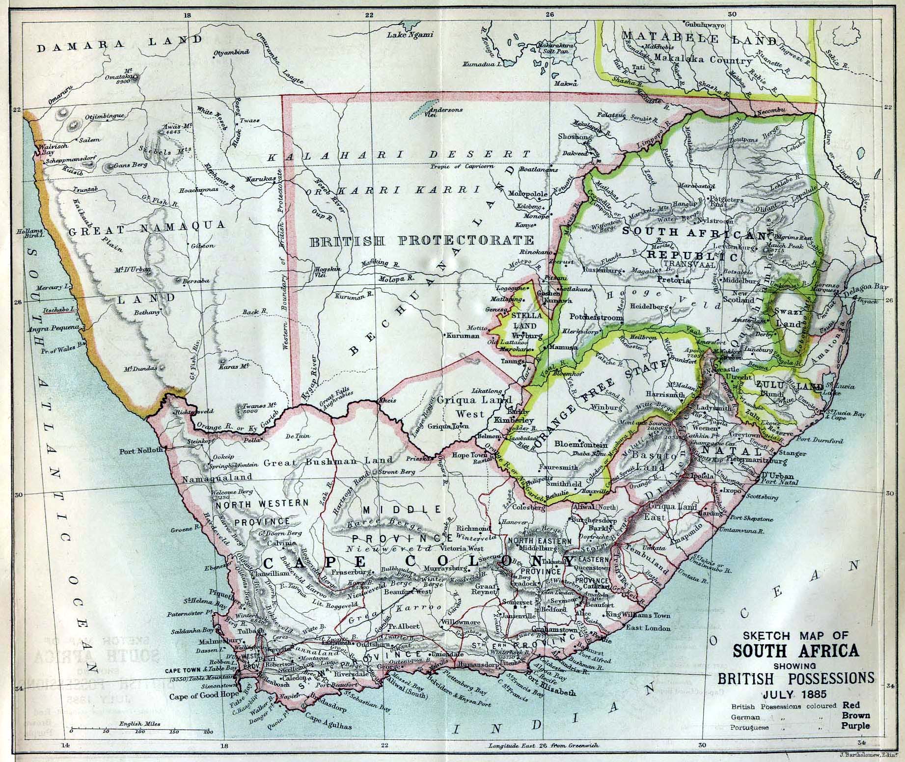
Note provinces on map.
Anyone have more information perhaps ?
...which Included
(When the Union of South Africa was formed).
The following regions were set up as homelandsdeclared independent of South Africa
Transkei on 1885 map as are east of Gret Kei River
1959 - Transkei became the first region to be established as a Territorial Authority; in 1963 it became the first Bantustan to be granted 'self-government'. dissolution 1990. See more at SA History Online Transkei Independence in 1976 and reintegrated 1994 as part of part of the new Eastern Cape province.
See more at SA Africa Online Ciskei Self governing in 1972, nominal independence 1981 and reintegrated 1994 as part of part of the new Eastern Cape province.
...split into three smaller provinces: 

Meaning area beyond (or "trans") the Vaal River,
Zuid Afrikaansche Republiek
See Original Map of the Transvaal or South-African Republic.
Zuid Afrikaansche Republiek
formed out of the bulk of the old South African Republic after the Second Boer War.
(When the Union of South Africa was formed) split as follows
The south-central portion (including (Pretoria-Witwatersrand-Vereeniging) became
The northern portion
The south eastern portion
Mostly came from the southwestern portion of the old Transvaal
See Map of South Africa during the South African War (1899-1902), showing British South Africa, the South African Republic, the Orange Free State, Portuguese and German territory
1823 to 1848 region known as Transorangia
The Griquas were the first people from the Cape to settle in the Transorangia area, beyond the Orange River 1820's .
Known as Soutern Transorangia around Philipolis mission station
The Voortrekker Republic of Natalia, founded in 1837, administered the northern part of the territory through a landdrost based at Winburg. This northern area was later in federation with the Republic of Potchefstroom which eventually formed part of the South African Republic (Transvaal).
Winburg part of Republiek Natalia before 1848
Recognised as an independent territory under the Bloemfontein Convention in 1854.
...Boer Republic
Discovered by the Portuguese explorer Vasco da Gama Christmas 1497, and named Terra Natalis (later the name Natália). Natal means Christmas in Portuguese.
Founded in 1837 after a Voortrekker victory against the Zulus at the Battle of Blood River.

To join the project use the request link under "actions" at the top right of the page.
Visit
 Go to
Go to
South Africans' Geni Landing Site. WELKOM CUZZINS!
First port of call for South African GENi